
Monuments, megabytes and pixels: about modern documentation techniques

The turn of the second and third millenaries is a period of a violent development of measuring techniques and of an equally rapid perfection of digital image processing. By combining innovative measuring and photographic techniques, the recorded image becomes part of a dimensioned and defined space. In this way, the methods of faithful imaging of a research object and the attribution of universal spatial attributes to it permitted to achieve far-reaching modifications of this technique. If we add new database systems merging maps, illustrations and codified information into a coherent entity, then we may boldly call digital revolution the extent of realized modifications.
An accelerated development of a methodology in various domains of the humanities, including those related to a broadly defined protection of the national heritage is noticeable since almost a quarter of a century. These changes concern not only research and conservation, but also – and perhaps primarily – the administrative domain covering the actions of the institutions and persons managing the resources. Thus let’s take a look at the major techniques, while remembering that the directions of their further development will escape the imagination of humanists. For we use tools created by engineers, destined – in a first instance – for engineers. Therefore, the possibility to use creatively the results of their work in the domain of protection of cultural goods compels us to have a specialized knowledge, imagination and intuition, but and above all an awareness of the objective for which these techniques shall be applied.
When defining the hierarchy of notions related to the application of the newest documentation techniques, the accuracy of measurements must be mentioned in the first place. It is no accident if the most important discoveries of the last decades concern equipment and computer software essentially used in geodesy. The precision of the imaging of some object, space or small surface, the bestowing on them of the features of a calibrated image inscribed into the local grid or endowed with global coordinates, this makes of the measurements a leading value. Measuring precision becomes the overriding factor, particularly when wide-area objects are concerned. This is a timeless imperative based on an objective, a constant value common to many techniques. Finally, this is a reference value, to which one may always refer, at nearly any level of technical or design advancement. This fact should be highlighted from the start, since – how surprising! – it often remains underestimated.
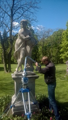
The foreground of innovative devices belongs to the 3D laser scanner. This instrument appeared in the sixties of the 20th century and, in an improved form, it became generalized by the late nineties. It performance is based on two methods of distance measurement: one is phase shift, the second the measurement of the time-of-flight. In both cases a laser light beam is sent to be reflected from the probed surface and returns to the device. During its action, the distance is calculated in a three-dimensional space, together with the horizontal and vertical angles making up the so called polar coordinates, subsequently transformed into Cartesian coordinates (x, y, and z). The scanner head rotates 360 degrees horizontally, recording the entire available space or a freely selected area. The scanner generates an image of an environment represented in the form of a so called point cloud. As the light beam may encounter many obstacles on its path, not all the surfaces may be documented from a single scanner location. To obtain a complete measurement and a three-dimensional imaging of the space, several (or more) scans must be made. The results are then merged into a whole with the help of dedicated scanning software.
The obtained image is constituted of millions of points and produces an accurate, three-dimensional model of the documented site (space). New generation scanners feature digital cameras, owing to which the image acquires natural colors (color point cloud). Each of the millions of points is described in the computer memory with coordinates, translating the record into a dimensioned digital model with an accuracy measured in millimeters. This is the basic result of the scanner’s work; any further processing will depend on intentions and on the effectiveness of the software used. In this way, on the basis of a scan we can obtain views of an entire mass (space) and its freely selected elements. We are capable of measuring distances, angle values, surfaces and volumes. It is possible to generate any number of cross-sections in selected places. Owing to these possibilities, it is possible to create CAD drawings in two or three dimensions. Finally, it is possible to present the scanning results in various forms, creating a basis for three-dimensional visualizations and the export of the work results in various point cloud formats and CAD.
Scanner application potential is enormous. Even if lately its popularity decreased on behalf of an emergent digital photogrammetry, the value of the scans as a reference source is undisputable. A particular attention needs to be paid to the rapidity of recording and a measuring precision unattainable by any of the previous techniques. Thus, scanning is now the best form of documentation at the reference set level. It is an image of the recorded space frozen in time. Measuring precision allows the scan to be used as a basis for the assessment of the state of preservation of monuments and of the changes occurring over time, booth as surface alterations and angular deviations. This is an ideal model for design purposes and for the production of historic monuments’ duplicates. A universal, fully objective image obtained with the scanner creates a value acting as a platform linking multiple scientific domains and introducing conservation into the circle of actions crowning the exploratory process. This is an important trait, worth remembering.
While staying in the “world of light beams”, it is essential to mention a technique rapidly capturing the research and conservation “market”. This is the LIDAR (Light Detection and Ranging), commonly known as airborne laser scanning. This English acronym means light-assisted detection and localization. Without going into details, this device is a combination of a laser and a telescope. Its functioning resembles the functioning of radar. The LIDAR differs from radar in that way that instead of a sonic impulse, it emits a light beam. At present, this is the quickest manner to create digital terrain maps. Existing software allows performing a comprehensive analysis of topographic details, also in places inaccessible to other forms of aerial recording, i.e. like the configuration of wooded areas. These features made this technique particularly popular with archeologists. It ought to be mentioned here that this is another measuring method providing a calibrated, three-dimensional image created from a point cloud. In addition, the contents of such image may create a wide spatial context for phenomena being of interest to us. Thus again, this space becomes a factor expanding our field of observation and creating a credible basis for interdisciplinary endeavors. All this may be particularly useful when administrating the space of historical parks and gardens. Until recently, the access to this technique was limited, mainly because of its high costs. Now, a major part of our country is covered by LIDAR measurements accessible in the web. The http://www.cotgik.gov.pl site offers against a small fee a map of any area that may interest us.
When writing about three-dimensional scanning, it is impossible not to mention the structured light scanning technique. This method uses the effect of the distortion of a line of illumination with a narrow band of light projected on the surface of the documented object. Straight beam lines are distorted when hitting the irregular surface of the object, then recorded by a camera and analyzed by a computer. In opposition to previously mentioned techniques, structured light scanning is used to accurately record small and average-sized objects. The development of this technique resulted in the introduction of measuring devices having micron precision and leading to a still ongoing discussion about the need to enter a world of precision difficult to apprehend for the human eye. Any decision about the scale of accuracy of the documentation produced should be left to persons determining the form in which it is collected and used. However, we must remember that any final product ought to functional and the choice of its form (therefore accuracy) should be the responsibility of the persons who placed the order.
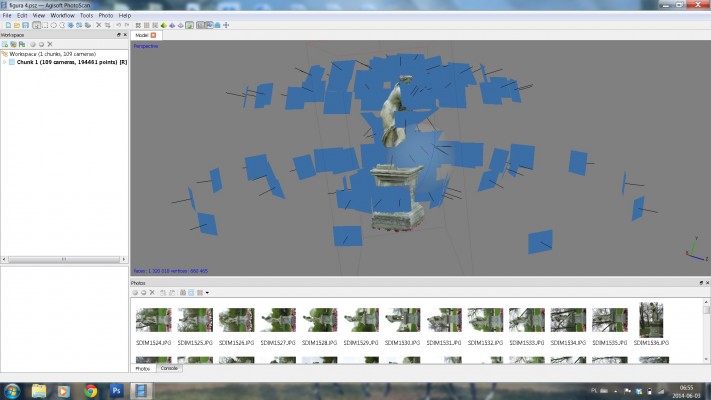
When mentioning the structured light scanning technique, I touched an issue being another significant feature of modern documentation techniques, namely the photorealistic faithfulness of a two and three-dimensional image. In this domain, the foreground is taken by techniques based on an exploitation of digital photo characteristics. A vigorously growing photogrammetry is the scientific domain where photographic image processing results in a definition of the dimensions, shape and location of a documented object. This technique gained popularity in recent years mainly owing to the function of automatic image stitching. Due to this feature, the general opinion is that this is a banally simple technique. This is not true. The final quality of projects relying on short-range photogrammetry is influenced by so many factors, that we need indeed to focus on the basic problems stemming from its use.
The essence of this technique is included in its name; essentially, photogrammetry provides an image composed of two layers: a photographic imaging and a measurement realized with geodesic equipment. The latter element, often omitted by the fans of automatic image stitching, ensures that the realized documentation occupies the right place on a wider scale and achieves precision at the local scale. To obtain metric (scaled) photographs, it is necessary to superimpose a grid over the recorded space. This is realized with a set of points defined by x, y and z coordinates. These may be fixed markers, or characteristic points within the limits of the documented object. Although certain techniques allowing to bypass this requirement (the ATI system) have been marketed, much time will pass by before they become commonplace. For the moment being, photopoints serve to determine the external orientation of images and to ensure an adequate precision to the final product. When selecting measurement points, care must be taken to position them (in the case of markers) at a correct angle in respect to the axis of the lens and the measuring beam. Also, an adequate camera and lens need to be chosen, as depth of field control and the choice of optimum weather and lighting conditions require a particular attention. The result of our work will be satisfactory both for the author and the client only if these conditions are observed.
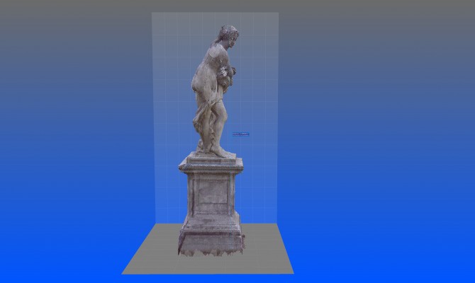
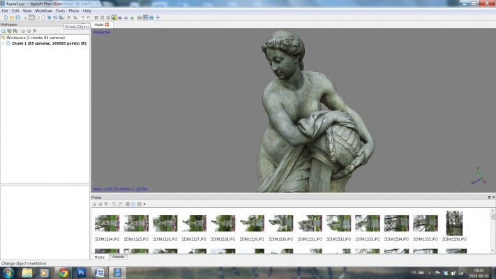
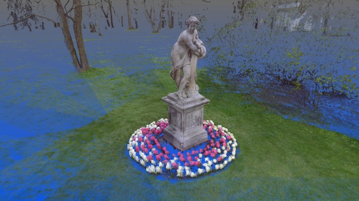
Concurrently with the development of digital photography, companies manufacturing photogrammetric software took care to provide tools not only enabling us to assemble a three-dimensional image with a set of photographs, but also to create automatically a three-dimensional model - surface or volumetric. At this very moment we can obtain models compiled from a point cloud and a triangular grid, not to mention texturized, thus photorealistic models. And even if in the case of a complex surface or volume the precision of this model may give way to some justified reservations, undoubtedly the development of this domain evolves towards the use of photographic cameras as optical scanners. It ought to be noticed that short-range photogrammetric software is successively modified and improved, owing to which calculation algorithms become more and more reliable.
Since scanning and photogrammetric processes provide products with similar characteristics, nothing prevents these techniques to be combined. Already, certain manufacturers add to their scan processing software packages photogrammetric overlays allowing to automatically combine both products. Once again I will dwell on the importance of precision, for this feature allows merging techniques as well as diverse methods of their realization, like the combination of surface scanning with aerial photogrammetry (i.e. with drones). This is a highly significant advantage of hybrid methods, which may be much more helpful than in a simple filling of a recorded space (volume) with hardly accessible detail. Undoubtedly, this new, combined manner to produce documentation is the best solution at the current stage of documentation techniques development. Hitherto practices, including those used by the Łazienki Królweskie Museum in Warsaw, allow looking forward to this trend with optimism.
The fact that a hybrid method was recognized to be the optimum solution in no way means that particular techniques do not fulfill their role. When attempting to use them, the basic problem concerns an adequate, fully conscious choice.
Laser scanning serves slightly different purposes; other effects will result from structured light scanning or short-range photogrammetry. From an engineering point of view, from the perspective of planned design work, particularly a large-scale one – the intention to monitor the state of preservation of historical monuments and the speed of realization of precise spatial recordings – the “power” of a laser scan has no competition at present. Yet, a measurement precision combined with a simultaneous and faithful image of a documented object remains the domain of structured light scanning. Photogrammetry is a relatively rapid method of visualization with a variable degree of accuracy, depending on the recorded surface.
The weakness of all above mentioned three-dimensional techniques are the difficulties stemming from documenting smooth and shiny surfaces. Although the newest types of laser scanners greatly minimize this imperfection, nevertheless a full success is remote. Some hope is seen in the development of the infrared-based Kinect technique. This is the newest way of recording a three-dimensional reality, presently mainly used as a motion sensor in popular computer games. It allows the user to interact with the console without the need to use a controller (by way of gestures or vocal commands).
Relatively recently materialized another opportunity for technical improvement, consisting in a selective use of the effectiveness of interactive computer games software engines. In this field, the experience of the Łazienki Królewskie Museum seems quite promising too. These methods rely on a technology capable to ensure that an image remains faithful in respect to the precision of the measurements taken. Thus opens a new field of exploitation for the fans of an active digital documentation combined with the magic of virtual reality. In the result of this type of actions, it is possible to obtain a structurally simplified – although much more attractive visually – and active archive taking into account an attribute based on documentation layers interaction and virtual reconstruction.
The ease with which three-dimensional models are generated from a documentation level using various techniques gives the opportunity for their manifold use. It should be remembered, that depending on the technique used and software merits, we can obtain virtual models in any scale and of an almost unlimited accuracy. They can be used as part of a reference documentation database, as an illustrative material easy to use for popularization, promotional or educational purposes (particularly when creating reconstructive animations), but also to create faithful copies of historical monuments. In this last case, technical advance brought an interesting solution, like the possibility to create three-dimensional “prints”. 3D printers capable of providing a faithful graphic mapping of spatially documented objects are undoubtedly a 21st century achievement. These devices open hitherto unexplored strata of human imagination. And it seems that they may prove to be particularly fruitful in conservation and in museums.
The opportunity to store in a computer memory an image of space which, owing to the most recent technique, becomes active in its every field, created a chance to endow recorded elements with geodesic positions or a photorealistic aspect, but also to define its full characteristic. Thus was open the road to a multilayered, interdisciplinary database capable of connecting the contents of a geodesically measured space or a three-dimensional georeferenced model with specialized contents. Nothing prevents the construction of a precisely metrically and graphically defined environment in which may be located various types of information collected by representatives of different specializations and scientific disciplines, entered at various stages of research and at different administrative levels. This is an environment processing and analyzing collected knowledge and spatial data, an effective tool at every level of administering a historical space.
This system is the GIS (Geographic Information System). Its might resides in its universality, as the GIS foundation relies on objective and invariable data: the geodesic coordinates. We may enter in the memory of a computer nearly all the categories of phenomena; the structure of a consequently assembled database will depend on our knowledge, experience and imagination. It is difficult to say which one of the enumerated features is the most important. Probably each one will need to be activated when creating the system, for we must remember, that the power of the created spatial database should rely on a possibility to merge its particular segments. The important point is that all the available of-the-shelf systems, including the ones that are free-of-charge, provide a possibility to modify and add new content. The result is an active archive with functions ascribed to new content sorting and analysis. This process can encompass any chosen space, notwithstanding its area, as well as any volume, notwithstanding its size. This easily accessible compendium of knowledge can be presented on the web with the help of built-in applications, naturally having various levels of access to the data store. It is a modern visit card of a well-administered organization.
Finally, it is worth to focus on another significant aspect of ongoing transformations. Now, the manner and the speed of introduction of innovative documentation techniques, the dynamics of computer hardware progress and the uncontrolled flooding of the market with new software solutions effectively thwart the possibilities to develop ultimate standards. It is pointless to plan long-term development in a situation where changes happen quarterly or in half-year cycles. Thus remains the obligation to maintain invariable and objective values – an imperative as far as measurement precision and image accuracy are concerned. A second task area for those, who decide to use modern techniques, is an obligation to work on and to implement basic values definitions, to establish thesauruses of basic notions allowing to maintain an order and unambiguity crucial in computer systems. This is a fundamental task providing the opportunity to use creatively the new techniques’ power in all the areas of their exploitation: management, promotion, custody, scientific research, conservation, popularization and education.